May 2014
Seen hundreds of pictures from Grand Canyon over the years and it's been looking nice. However, it's been said that only after seeing it live for the very first time one realizes it what it really looks like.
This in mind headed towards South Rim of the Grand Canyon on Memorial Weekend. Masses of people had made the same decision, unfortunately.
When you arrive the National Park, you see deers and pine forest, still no sneak peek of canyon. After arriving parking lot near Visitor's Center still no clue about the canyon.
South Rim lies above 2000m above sea level and itself is pretty flat. No mountains or high peaks on the rim. About 20 meters before Mather Point, probably the most used viewpoint on the South Rim, one sees the canyon for the first time.
At least my mouth stayed half open some time after seeing it for the very first time (few wow's, too). First reaction, it massive, no, it's bigger than massive. Next thought, all colours of different layers. One more observation, there's no (Colorado) river in sight, was it dry as it couldn't be any deeper in canyon, could it? One more thing, walls of the canyon looked steep, really steep.
Next, taking a bus to the trail head. There's a free bus routes along the Rim, a really great idea instead of thousands of cars.
Had decided to hike down to the Colorado river via South Kaibab Trail, and assuming to return via the very same route. A few others started the same trail, not sure how many of them had the river in mind as warning signs everywhere told do NOT to try to hike to river and back in one day.
Took some time to get to used to steep walls and trail on edge of them. First zig zagged one side canyon until arrived at the ridge. Red dust of sand on trail covered soon hiking boots. On ridge the canyon opened 180 degrees, from west to east, for the very first time. Very soon you noticed the South Rim being somewhere up in there and size of human being on viewpoints became tiny ones.
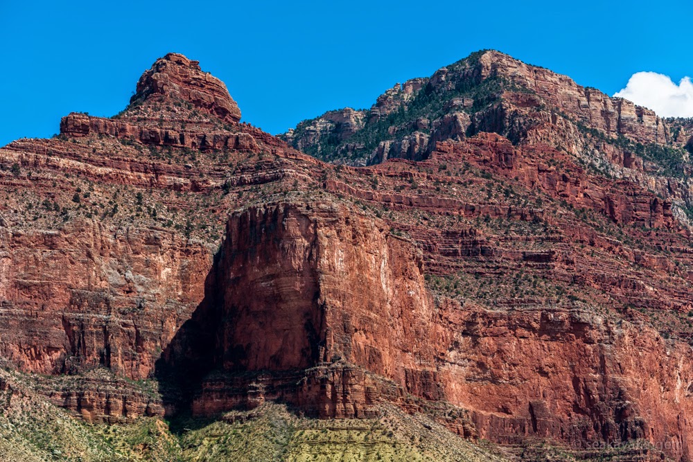
The sun hit straight towards some temple formed mountains there. Different variations of red colour emphasized their form.
The trail was nice staying on ridge as it allowed good scenery on every direction. The sun started to warm more and more while descending to the bottom. For first time it felt weird to start the hike descending first and the hike would be ended by steep ascend.
Still no sight of the river yet when met a first group of mule riders. "Pitstop" some rider yelled, all riders halted their mules and one of them did an urgent nature call on the trail. All happy faces within a group, though to me a bit scary on some steep sections of the trail.
Passed the first crossing of another trail, Tonto Trail, which headed in parallel of the Rim but few hundred meters down in the canyon.
Saw only few people heading more down to the canyon. Most of them had turned back, wise decision.
Stopped a couple of times to listen could one hear the river which was still not in sight. No, absolutely no sounds of floating waters. Suddenly after few turns in steeper section saw the first sight of a green river, dunes and some trees. Still far away somewhere down there. Couldn't fully see up to the Rim anymore either.
All the way down couldn't keep my finger off the shutter button of a camera. It felt more a duty than any guarantee of capturing breathtaking photos.
Zoom lens helped to spot few people down on the trail as well as on sand dunes near the river. The Colorado River. In Grand Canyon National Park. It felt just great.
One started to feel constant descending on legs, which became heavier. The sun heat the air which felt much warmer down there than high on the Rim.
Brave steps on a narrow walking bridge and crossed the river. The very first thing was to rush down to the sand dunes, take off the hiking boots and socks and wade to the river to cool down feet. Boy it felt freezingly cold! Didn't the sun warm it at all (learnt the reason from a wikipedia later)?
Salty snacks, electrolyte drinks and lots of water. All other hikers did the same steps, by nature.
The river was about 50-100m wide, having easy looking rapids every few hundred meters.
After crossing the bridge, the name of the trail changed to North Kaibab Trail. Continued a short distance while crossed a tiny Bright Angel Creek and arrived at a small cabin. The main point to stop there was to get fresh water. CamelBak was becoming empty so having fresh water here was kind of a mandatory task. A mule deer watched in short distance while I filled in water bottles.
Asked few other hikers which way they'd decided to return. Most of them said Bright Angel Trail. Hmm... that's other trail than my plan was. A quick view to the map showed that it was few miles longer but had a couple of important water sources within the trail whereas South Kaibab had none. After considering a second or two decided to head towards Bright Angel Trail.
The trail name was now called Bright Angel Trail. It followed the river, crossed the river via another walking bridge and then followed again the river on the south side, staying quite near the water level.
After one bend came across rafting boats on a shore. People were preparing to move back to the river and its rapids there. Mule riding and rafting were popular here, having about a year's queue to guarantee a place in them (I'd pick rafting for sure!).
The South Rim was not in sight from the river, rapids brought the sound level which covered any other sound or noise.
Arrived at the Pipe Creek and Pipe Creek Resthouse. Now the Bright Angel Trail left the Colorado river and turned back towards South Rim. The trail stayed on a narrow canyon. Steep zig zag trail, no wind, temperature now well above +30C, it really started to feel a heavy hiking trip. Met other hikers and sharing heat and steepness made hiking easier. Bighorn sheep with horns came down extremely steep wall, how on earth their braking system will work?
Soon after crossing Tonto Trail again arrived at Indian Garden Campground. Lots of tired hikers there filling in their water bottles and staying in shadow of the sun. The trail was in a steep canyon, having a tiny creek and lots of trees. Another type of scenery, as the walls of the canyon looked so steep that it looked impossible to get out from there.
Slowly ascending with others arrived soon to the other hut, with fresh running water in there, called 3 Mile Resthouse. It laid on steep edge proving excellent view towards North Rim. No sight or sound from the river anymore.
Last kilometers were tough, really tough. It was such a relief when the South Rim was suddenly in sight again. 30 km down and up. Happy but exhausted. Very exhausted.
At least one thing had now changed forever; every single photo of Grand Canyon will now look different (and there's a burning desire to go hiking there again, or maybe rafting on Colorado River ...).
Some photos
A few of them have people in them (those tiny dots), just to help to understand the scale |
| The very first view to Grand Canyon, just wow! That's what it felt |
 |
| Wouldn't dare to very edge, brave people |
 |
| Isis Temple |
 |
| First kilometer on South Kaibab Trail |
 |
| Ooh-Aah Point |
 |
| On ridge |
 |
| Zig zag |
 |
| On edge |
 |
| Pitstop! |
 |
| Local transportation |
 |
| Greenish |
 |
| Soon on river. Not yet. Spotted hikers? |
 |
| Crossing Colorado River! |
 |
| Lunch company, a mule deer |
 |
| Preparing for rapids |
 |
| On action, paddle, paddle! |
 |
| Bighorn sheep rushing down on steep edge |
 |
| Spotted hikers? |
 |
| Hmm... more than 500m vertical still to go |
 |
| Banana Yucca |
 |
| Some shade on Indian Garden |
 |
| 'Roadwork', only one lane in use |
 |
| Last km's were toughest |
 |
| Some happy hikers descending on Bright Angel Trail |
 |
| The Battleship on early evening sun |
 |
| Showers hit on North Rim |
 |
| Through the tunnel and you're almost done |
No comments:
Post a Comment