July 2012
Did a two-day trip to the Repovesi National Park. It was a combined trip, where the Day 1 spent in a kayak paddling around Lake Repovesi and Day 2 spent hiking, mostly in the northern part of the National Park.
The Repovesi National Park is located in Southern Finland, about two hours drive towards north east from Helsinki.
Got an idea of visiting there last winter when I met two of its representatives at an Outdoor Exhibition. During the same Exhibition, the Park was announced to be the Trekking Destination of the Year 2012 in Finland.
Looking back now the whole trip, it was really nice. It was worth visiting there, to see the area, feel nature, and especially to get all such experience via both activities, kayaking and hiking.
Day 1
Arrived very early in the morning to Lapinsalmi parking area, one of the three entry points of the Park. The sun was shining every now and then. Clouds were dark, hinting rain, or showers at least. Temperature allowed to start with short sleeves.
Had packed all stuff previous evening and bought all food from the local store near the Park (incl. fresh strawberries!).
Lapinsalmi had a nice entrance welcoming visitors of the Park (the kayak was mine though):

Carried the kayak and all other stuff to the lake, about 100m off from the parking area. At the lake, there was a pier made specifically for paddlers. Really easy for landing (similar piers appeared to be on several places around the Park). Good service!

Had earlier bought an Outdoor Map of the area, in scale of 1:20 000. It was a paper map thus needed to protect it in Ortlieb's Map Case.
Wasn't sure how easy it was to carry the kayak from one lake or pond to another. Carrying all stuff in the kayak, plus having +10 litres of fresh water didn't encourage long carryings. Studying the map one quickly learned that lakes and ponds were small so not much paddling in them. Thus decided to stay on Lake Repovesi alone, although did look opportunities to carry if other lakes/ponds looked attractive for paddling. Therefore headed first towards south of the Lake Repovesi, which on the map looked shorter for paddling than the part of the lake north from my starting point.
Shortly after the start arrived at the self-service ferry, which hikers were able to use to cross the narrow water passage. Just pull the rope, Cool!

From the very beginning noticed variety of birds flying here and there. Herring Gulls screamed, but then spotted this lady with her baby (not sure, but was it a female Common Merganser?).

Clouds were getting darker. Soon wind rised. It didn't take long after it started to rain, and boy it did rain heavily. Was wearing a short sleeve Merino but felt a bit cold. However, clear blue sky was not too far so continued paddling in the rain. Merino T-shirt is good as it dries quickly. So it was the case here, too.

The rain stopped soon and wind calmed down, too. Paddled south through narrow passage ways of the lake and circled Ottapajansaaret, a group of islands, and then headed back north, now paddling near east side of shores.

Wind kept hiding almost completely in small peninsulas:

On Terrilahti Bay, saw a high rocky hill for the first time. It did look massive, in a scale of what can be seen in southern Finland:

Continued paddling north passing the starting point. Very soon after came perhaps to the most visited point of the Park, Lapinsalmi Hanging Bridge. There was a Campfire Place, as well as a pier for paddlers. Had about 10km paddling behind, thus lunch break came at good time.
Several groups of hikers and other daily visitors were cooking their meals. Enjoyed the lunch, took some mandatory photos and chatted with other hikers. A pity that it stayed cloudy the whole time.

Off to paddle again, heading towards Kuutinlahti Bay. The next big rocky hill was Katajavuori:

On Kuutinlahti Bay noticed that water level was low:

Rocks, trees and white Waterilies and the whole nature urged taking photos. From the kayak I used a waterproof point and shoot camera whereas on land I used a DSLR (carried in a waterproof bag).

Landed on Kuutinkanava Campfire Place, yet another famous stopping spot. There was a wooden made canal between the Bay and Lake Tervajärvi. There's some story about the canal here. Took some photos there. For now it was crystal clear to me that I would stay paddling on Lake Repovesi and not to carry my kayak to smaller lakes, e.g. here to Lake Tervajärvi (in about 200m distance). Too much carrying and effort for a relatively small lake for paddling.

Very near Kuutikanava Campfire Place there was yet another high rocky cliff which had partly collapsed. History books told me that it happened 9300 years ago. Not sure anyone witnessed it in situ.

Paddled to Sammallahti Bay, landed there and walked through forest to Olhavanlampi pond near by.
On Olhavanlampi, there was something special to see. Not only of its very high rocky hill, about 50m high Olhavanvuori, but it was the highest rock climbing hill in Finland. It did look truly fantastic with some climbers in there. Something that I'd really like to try one day.


Back to the kayak and heading out from Kuutinlahti Bay towards north.

However, there was one and last thing to see, i.e. a prehistoric rock painting in a massive cliff near by:

This was surely the smallest island I'd ever seen:

Shores started to be full of small rocks:

A Solar Panel?

The sun appeared every now and then being mostly cloudy. However, wind had strengthened and gave a strong tail wind. Had earlier decided to stay overnight near starting point. Was slightly worried about it as soon after reaching the most northern point of the lake had to change back to south and paddle at least 10km in strong head and side wind.

After some paddling reached Camping Site. Paddling was tough. Wind in gusts raised waves, perhaps up to 50cm high.
When landed, first thing was to go swimming. Next thing was to cook a dinner. Some pasta, followed by fresh strawberries. Yummy (latter, not former)!

Herring Gulls kept walking close and flying around me during dinner time. Not sure did they really want my pasta?

Wind had calmed down. Mosquitoes tried to bother me. However they were not in a large scale and thus had a quite comfortable evening to spend.
People visited late in the evening on the Hanging Bridge:

Scenery around me looked nice:

Couldn't resist of shooting willows and their reflections on water:

Then saw some paddlers bypassing. Two inflatable kayaks:

Sounds of Loons kept continuing. They were marvelous. Birds kept flying near by, too:

Even some fish came on surface of the lake:

This wooden log in the lake encouraged to try black and white photography. Well, this colour one did look better though:

Calm lake and reflections on it looked nice. Was hoping to see sunset but had no luck at this time.

Weather forecast did promise rain for the night. Wanted to try of how an eVent based Bivy bag would work. Had a Plan B, i.e. a tent in a kayak in case for a disaster. Well, the heavy rain came and soon felt some moisture inside. Decided to move to the Plan B. Quickly setup the tent. However, did notice in the morning that the Bivy bag would have had a cover for zippers which I didn't setup properly. Bivy bag test in a heavy rain was fun, too, it did feel great as raindrops hit hard on it feeling strange to be dry so near of heavy rain.

Day 2
Heavy rain which continued during the night had stopped when I woke up. It was cloudy. Heard buzzing sound of mosquitoes. Worrying.
Packed the basecamp quickly, then a breakfast; scrambled eggs with awful instant espresso coffee.
Had discussed earlier possibilities to leave the kayak in a safe place while hiking. That place was in the northern entry point, Saarijärvi. Thus, quickly paddled to Lapinsalmi, packed all stuff from the kayak, and the kayak itself, into the car, and drove to Saarijärvi entrance.
Weather forecast predicted showers. It did twice for a short period only, otherwise it stayed nice and warm for all the day.
Arrived at Saarijärvi. The chap there allowed me to leave the car and a kayak behind locked gates and in front of his eyes. Really good service again, Big Thanks!
Was wearing approaching shoes (with waterproof socks, too), thin softshell pants, and a Merino T-shirt. Carried a thin gore-tex pullover, too. In a backpack had some water and food. In addition to these had a paper map and a DSLR. Heavyweight, sort of.
With no exact plan for route, started to hike towards Lake Valkjärvi (according to some statistics, there are some 180 000 lakes in Finland. What's the definition of a lake or a pond, their sizes and characteristics, I simply don't know. So bear with me when I switch between them). First meters were on a sand road. Very soon saw a nice looking small pond on the right. It was Tolonen:

Arrived at near Lake Valkjärvi and its first Campfire Place, Sukeltajanniemi. Nice spot:


And this what the hiking path there looked like, Lake Valkjärvi on background:

There was some area of burnt forest, too. Perhaps artificially done:

All official Campfire Places had ready made wood logs:

Arrived at the other Campfire Place, called Valkjärvi (still on Lake Valkjärvi). No complaints.

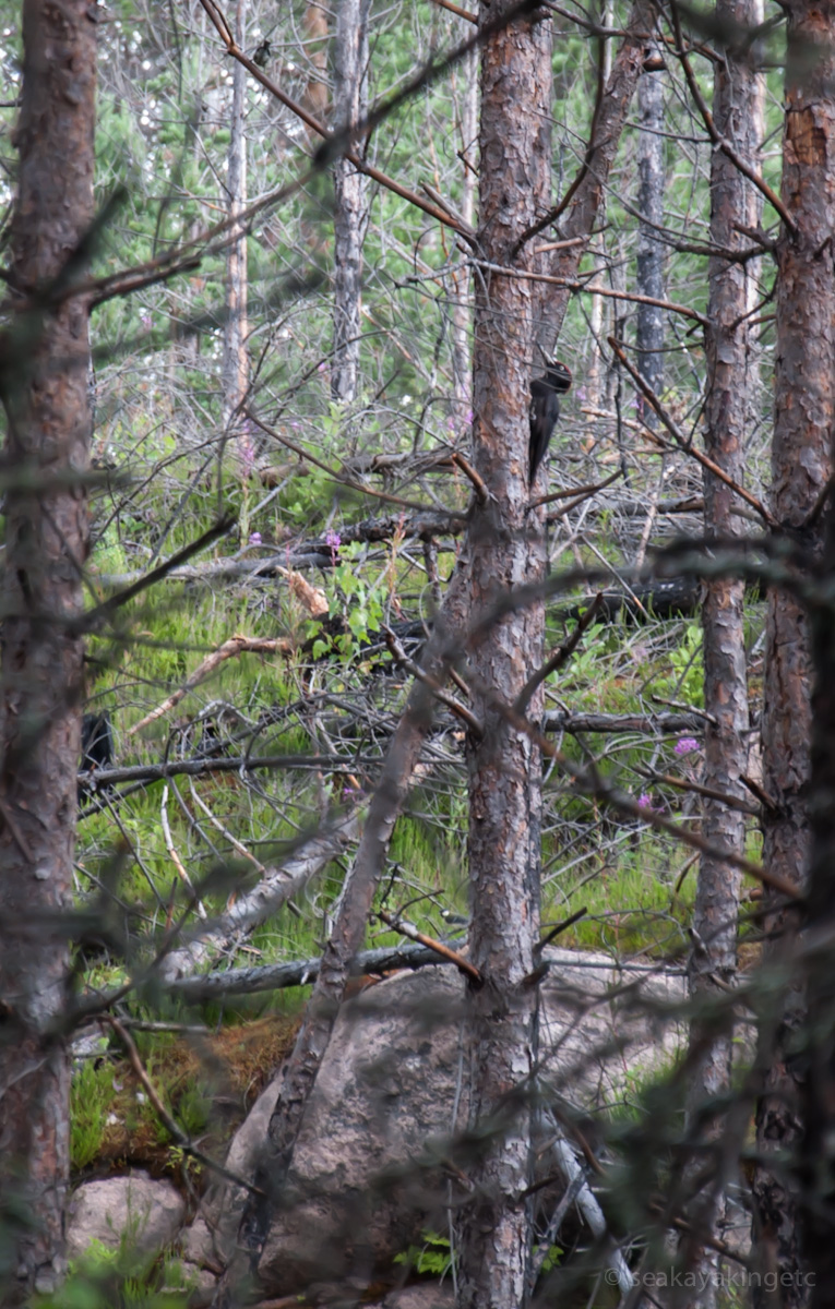
Was time to decide where to continue. Had an idea of seeing the highest hills and lakes/ponds near them. Soon was heading towards Olhavanvuori hill. On my way there saw a Woodpecker:
Reaching on top of these hills did raise a pulse. However, the view e.g. from Olhavanvuori hill was worth of it:


Descended from the top to the pond level. Red Throated Loon floated on Olhavanlampi pond. Wind was nowhere, thus reflections on water begged some DSLR usage:

There were no climbers yet (too wet, or slippery):

Had become hungry on recent ascendings and descedings. There was a Campfire Place very near. Saw some smoke rising from there. It was about time for a lunch. Met two guys there, they'd been hiking and climbing about a week. Grilled a couple of sausages on open fire. After nice chat and the lunch, continued hiking, headed towards Mustalamminvuori hill. The hiking path went near Mustalampi pond:

When reached on top of the Mustalamminvuori hill, saw big black birds floating over the hill, like Eagles. No, they were not Eagles but Ravens:

On the top of Mustalamminvuori hill, there was a watchtower, from where scenery on any direction couldn't have been better, like this one towards Kuutilahti Bay:

Descended to water level again and was soon heading towards Kuutinkanava Campfire Place. The hiking path went near Kuutinlahti Bay:

A Waterlily, did look beautiful indeed:

One had to circle a collapsed cliff above of it, thus yet another sudden ascend and descend was needed. Sweating.

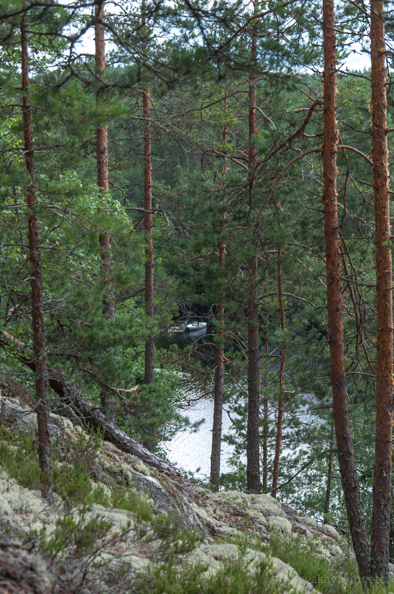
But it was worth of it, saw a small boat on Kuutinkanava Campfire Place:
Another view from the same place as above, now showing Kuutinlahti Bay better:

And this is what the Kuutikanava Campfire Place looked like:

It was about time to return to car. Had some 10km already behind. Decided to take a bit more forest route back. First hit to Kuutinlammit ponds:

There was not only a buzzing noise, mosquitoes did hit me constantly with no rest. Tried to fight against them with not much luck. Despite of them, took some photos, too, like these raindrops on Lily of the Valley leaf:

Type of forest, and type of trees in them, changed constantly:

A rare view, a lonesome big mushroom:

The route passed near Lake Valkjärvi again, this time on east side of it:

Can you hear the buzzing noise? When I look this photo I can still hear their sound (or noise):

Terrain changed again. Moss, type you see more in Lapland, was dominated here:

And there were some bogs, too:

About half of the Repovesi National Park is prohibited from public, as it belongs to the Army. The route went very near so called border:

Arrived at Saarijärvi place after 15km of hiking. Had a coffee with the chap. Then went to swimming on Lake Saarijärvi. Good to clear off all sweat. Happily and not too exhausted ended this two-day outdoor trip.
When leaving, saw this sign. It put me smiling and left many happy memories

GPS recorded route, 15km altogether (view in a larger map):
<end of story>